

Special Edition: Mapping the Valley (March 26, 1862)
Special Edition: Mapping the Valley (March 26, 1862)

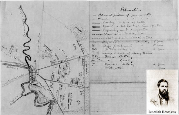
On March 26, 1862, Thomas J. ‘Stonewall’ Jackson called Jedediah Hotchkiss, his thirty-four year old volunteer staff aide, for a meeting at his temporary headquarters in Woodstock, Virginia. Prior to the war, the New York born Hotchkiss had studied the geography and geology of the Pennsylvania and Virginia countryside and taught himself the practice and principles of topographical engineering. He and his brother were operating the Loch Willow Academy near Staunton when the Civil War began. He joined the staff of Lieutenant-Colonel Jonathan M. Heck on Rich Mountain in July 1861, and helped lead the retreat from Camp Garnett. He was promoted to acting adjutant and when Robert E. Lee arrived to take command, he assigned Hotchkiss to complete a map of Tygart's Valley, which passes through a gap between Rich and Laurel Mountain.
After a bout with typhoid fever, Hotchkiss returned to the army and joined ‘Stonewall’ Jackson’s command, along with the Augusta County Militia, in March 1862. After completing a preliminary reconnaissance with Lieutenant James Keith Boswell, Jackson’s Chief of Engineers, Hotchkiss was notified that Jackson had important work for him. Jackson's directions were simple and direct. "I want you to make me a map of the Valley, from Harper's Ferry to Lexington, showing all the points of offense and defense in those places.” With that order, Hotchkiss became Jackson’s official Topographical Engineer. At the time, the Shenandoah Valley, 150 miles in length and 25 miles wide, had never been properly mapped in detail before. Hotchkiss accepted the assignment and worked on the map for the remainder of the war.
Keep reading with a 7-day free trial
Subscribe to This Week in the Civil War to keep reading this post and get 7 days of free access to the full post archives.